Kanchenjunga Circuit TrekKanchenjunga Circuit Trek

Kanchenjunga Circuit Trek-19 Days

Key Information
  • Duration19 Days
  • Difficulty LevelModerate
  • Max Altitude5,143 m/16,873 ft.
  • Arrival CityKathmandu
  • Best TimeMarch-May/Sep.-Dec.
  • Group Size2-16

Introduction to Kanchenjunga Circuit Trek

The Kanchenjunga Circuit Trek takes you into the remote northeastern Himalayas of Nepal. It is an isolated region that was off-limits to trekkers until the late 1980s. 

This trek of Kanchenjunga Circuit is a truly off-the-beaten-path adventure. The trek is perfect for those seeking solitude and authentic wilderness. You will trek through a culturally rich area. The area is inhabited by Rai and Limbu people in the lower hills. Sherpa and Tibetan communities live in the higher elevations. During the trek you experience a fascinating mix of traditions and lifestyles as you go. 

Don’t be surprised when you are offered a warm cup of “Tongba”. Tonga is the local millet beer served with hot water. You might as well be offered other traditional foods and drinks in the villages you pass.

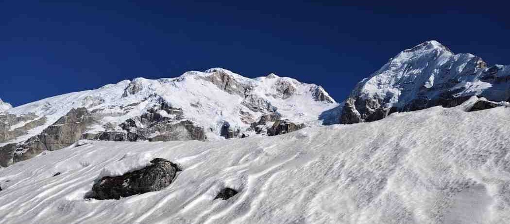
Kanchenjunga circuit trek rewards you with unparalleled mountain vistas. You will walk in the shadow of giants not only Kanchenjunga but a panorama of other famous peaks. 

Majestic view of the Kanchenjunga massif towers over the remote valleys. It is a rewarding shift for trekkers on this circuit.

What to expect during Kanchenjunga Circuit Trek

Over 19 days, the Kanchenjunga Circuit Trek leads you on an unforgettable journey around Mt. Kanchenjunga’s north and south base camps. 

The route winds through the Kanchenjunga Conservation Area (KCA), a 2,035 km² protected area established in 1998. The trek begins in lush subtropical forests around 1,300 m elevation and gradually climbs into alpine terrain above 5,000 m. 

This is a fully guided and teahouse-supported trek. You will have an experienced guide and porter team with you. You’ll stay in trekking lodges or homestays each night (no camping required, unless by choice).

Flora and fauna

Kanchenjunga Trek gives you a chance to witness dramatic changes in vegetation and wildlife. The lower valleys are blanketed in terraced fields and cardamom farms. The mid-hills feature dense forests of maple, chestnut, oak, and rhododendron. 

As you gain altitude, forests give way to juniper and alpine shrubs, then to rocky moraine and glaciated zones near the base camps. 

The KCA is a global biodiversity hotspot home to over 250 species of birds and countless flora and fauna. 

If you’re lucky, you might spot elusive wildlife. You can see the red panda (endangered species), snow leopard, Himalayan black bear, or musk deer in the forests. Colorful pheasants like the Danphe (Impeyan pheasant) and other high-altitude birds are occasionally seen darting through the undergrowth. 

Trekking quietly in the early morning increases your chances of wildlife encounters.

Geography and Terrain in Kanchenjunga Circuit Trek

Kanchenjunga circuit trek also rewards you with unparalleled mountain vistas. You will literally be walking in the shadow of giants not only Kanchenjunga but a panorama of other famous peaks. 

On the north side of the trek, you’ll come face-to-face with peaks like:

  • Jannu (Kumbhakarna, 7,710 m),

  • Tent Peak (also called Pangpema Peak, ~5,670 m),

  • Mount Kambachen (7,902 m), and

  • Chang Himal (6,802 m). 

In fact, from the Pangpema viewpoint at North Base Camp, you can even spot distant 8,000-meter summits such as Mt. Everest (8,849 m), Lhotse (8,516 m) and Makalu (8,481 m) on a clear day. 

After crossing to the south side, you’ll gaze upon the colossal south face of Kanchenjunga. The neighboring peaks are Kabru and Rathong in Sikkim. The trek also takes you to glacially-carved valleys and milky blue glacial rivers. During the trek you'll see Yalung Glacier on the south side and several smaller glaciers feeding the Tamor and Ghunsa Rivers. 

At the high passes, you’ll see an unending panorama of snow-capped mountains in every direction. It is a sight only a handful of trekkers get to experience.

Culture and Ethnicity

The journey is not only about mountains; it’s also a cultural odyssey. 

In the lower sections around Taplejung and villages like Mitlung or Chirwa, you’ll encounter multiethnic communities (Brahmin, Chhetri, Limbu, etc.). 

As you ascend, Limbu and Rai villages dot the hillsides. These ethnic groups are known for their bravery and unique customs. 

Higher up near Ghunsa and beyond, the population is predominantly Sherpa and Tibetan. You’ll notice Tibetan Buddhist monasteries, prayer flags, and perhaps hear the distant sound of a yak bell. 

The people here have a way of life largely untouched by modernity. They are renowned for their warm hospitality despite the harsh environment. 

Teahouse lodges along the trail are often run by local families; in the evenings you can sit by the kitchen hearth, warmed by a wood stove, and learn about local legends (including tales of the Yeti, which locals claim roams these mountains!). 

You can vist the centuries-old Ramtang Monastery or the Oktang Monastery in the south. It can be a spiritual highlight of the trip. The trip to monastery offers insight into the region’s Tibetan Buddhist heritage.

Kanchenjunga Circuit Trek 19 Days Route

Kanchenjunga Circuit Trek in the Himalayas will be a long walking journey. You will be viewing the mesmerizing view of nature and local peoples during the period.

After the scenic flight and drive through the green hills, we will finally reach Taplejung. As we start our walk toward high terrain and valley with a pleasant view of mountain peaks, we will be at Amjilosa. As we ascend up, we will witness an elevated landscape and beautiful valley.

We will then into the arctic zone at Kanchenjunga North Base Camp around a place called Pangpema. After we trek further, we will head towards the pleasant village of Gunsa. Our trial will then heads towards the southeast. We then pass through a beautiful forest of rhododendrons and pine trees as we cross Sele La.

After that, we cross Sinon La Pass to reach South Kanchenjunga Base Camp. As we trek ahead, we will cross Yalung Glacier, Ramche, Totongdin, Hapu Khola. After that, we will finally reach Kathmandu through Bhadrapur.

How Difficult is Kanchenjunga Circuit Trek?

We rate the Kanchenjunga Circuit trek as “Moderate-Difficult.” There are some major reasons this trek is considered Moderate-Difficult.

You don’t have to be a professional athlete to achieve the Kanchenjunga Circuit Trek. It doesn’t mean that the trek to Kanchenjunga is simple as walking or running in the park! A certain level of good health and training is required.

During the trek, you will reach 500 m to 700 m (in 6 to 8 hours) of elevation per day. If you have not experienced any high-altitude trek, it could be hard to reach a certain height.

The good thing about the Kanchenjunga Circuit Trek is that the height increased firmly before reaching the top. This makes easy to acclimatize and makes it relatively safer than other treks in Nepal.

The temperatures at Base Camp will reach the maximum of 15°C to a least -10°C with a wind speed of 8 to 10 mph. Weather of Kanchenjunga Circuit Trek might be one of the challenging parts after the North Base Camp.

Take extra attention and check the weather forecast, if are planning to finish the circuit. Weather-wise, this trek is likely 2nd most strenuous trek after Dhaulagiri Circuit Trek.

Acclimatizing should be top of your list when you consider the Kanchenjunga Circuit Trek. Always plan an itinerary with enough days of acclimatization between the trek.

The updated trekking route is for 17 to 20 days. Please do not be confuse if you see 26-30 days itineraries as they have not updating with the new trail changes.


Acclimatization and health: 

We deliberately include an acclimatization day in Khambachen (Day 7) and in Ghunsa or Lhonak if needed. 

Altitude sickness (AMS) can affect anyone above 3,000 m. 

Symptoms to watch for include headache, nausea, dizziness, shortness of breath, and fatigue. 

The golden rule is to trek high, sleep low  which we follow by taking day hikes on rest days and to descend immediately if symptoms become severe. Our guides carry a first aid kit and are trained in AMS response. 

We recommend you maintain good hydration (drink plenty of water, tea, soups) and avoid alcohol. If you have no prior high-altitude experience, consider doing some smaller treks. These smaller treks are like training hikes before this expedition to condition your body. 

Aerobic fitness (stamina) and leg strength are most important. With the right preparation, most reasonably fit hikers can complete the Kanchenjunga Circuit. 

Remember, it’s not a race; a steady, slow pace is key to success. 

Plan to arrive in Nepal at least a day or two before the trek to rest. If possible allocate a buffer day or two after the trek in case of any route delays. Delays can be sometimes caused by bad weather, flights delay. Sometimes landslides can slow road travel.

Kanchenjunga Circuit Trek Cost breakdown

When planning for the Kanchenjunga Circuit, one big question that arises is: How much will it cost? 

The good news is that trekking in this remote region is not as expensive as many assume, especially given the length and logistics involved. 

The typical cost for a 17-20 day Kanchenjunga Circuit package ranges from around US $1,500 to $2,000 per person, depending on the level of service and group size (this price usually includes guided trek with permits, flights, accommodation, meals, etc.). 

Our 19-day standard package is approx. US $1,625 per person, which is quite reasonable compared to other long treks. In fact, the Kanchenjunga trek can sometimes be more cost-effective than popular routes like Everest. The accommodation and food along the trail are fairly basic and priced modestly. 

One reason costs stay moderate is the growing number of teahouses on the route. You do not need expensive camping equipment or large support crews, as lodges provide beds and meals.

Several factors influence the total cost: trek duration, group size, and any added services. 

A shorter itinerary (say 17 days) might cost a bit less than a longer one with side trips. If you trek privately (solo or just two of you), the cost per person will be higher than joining a group trek.

We offer group discounts for example, a group of 6 or more people will get a lower per-person rate (sometimes around $1,450 each). 

The cost we quote is usually all-inclusive for the trek.

Essentially, once you arrive and join us, you shouldn’t have to worry about day-to-day expenses during the trek.

The main things not included would be personal expenses, travel insurance, visa fees, and tipping for the staff. At the end we list these in detail below.

One of the essential expenses for Kanchenjunga is the trekking permits. Do not worry, we will arrange permits for you in Kathmandu before departure. 

The Kanchenjunga region is a restricted area, meaning independent trekking is not allowed. You must have a special Restricted Area Permit (RAP) and be accompanied by a registered guide, with at least two trekkers in your group. 

The RAP fee for Kanchenjunga is regulated by the government (it can be around $20 per person per week in the region, subject to change). In addition, you’ll need the Kanchenjunga Conservation Area entry permit to support conservation projects. KCA costs around NPR 2,000 per person.

(Note: A TIMS card is not required for restricted areas like Kanchenjunga. You only need TIMS if you plan to trek independently into non-restricted areas afterwards). 

All permit costs are included in our package.

Overall, considering the length and remoteness of this trek, the Kanchenjunga Circuit offers excellent value for money. 

You get nearly three weeks of trekking, incredible scenery, and a fully guided experience. We strive for transparency below exactly what is included and excluded in our package pricing so you know where your money goes.

Kanchenjunga Circuit Trek Permit

As Kanchenjunga is a protected area, the government needs several permits to support the preservation of the area, limit the number of tourists and manage the borders with Tibet. These permits are required solely for Kanchenjunga Conservation Areas.

You will need 2 kinds of permits issued by the Government of Nepal.

  • Kanchenjunga Restricted Area Permit (RAP)
  • Kanchenjunga Conservation Area Entry Fee

Highlights

  • Beautiful mountains view of the third highest peak in the world-Mount Kanchenjunga central, north and south.
  • Visit Limbu and Sherpa culture and their regular lifestyle.
  • Remarkable valleys with amazing culture and regular lifestyle of Sherpa and Limbu culture.
  • Walkthrough the Cardamom farm.
  • Encounter with wildlife and domestic animals like yak, snow leopard, musk deer, red panda, etc.
  • Home of endangered varieties of birds like Impedance Pheasant, Red-Billed Blue Magpie, Shy Dragon, Amphibian, etc.
  • Pass margin-la pass and enjoy watching a beautiful mountain view.
  • Remoteness and untouched natural heritage inside Kanchenjunga Conservation Area which is spread over 2,035m sq. km
  • Diverse landscapes from forests to meadows.
  • Glorious sights of the frozen lake crystal clear stream, Okthan glacier, etc.
  • Traverse the most excellent picture of the Kanchenjunga trekking trail including Rathong and Kabru, glacial excursion around Ramche, etc.

Itinerary

Expand allCollapse all

We, The Himalayan Odyssey, will organize the Kanchenjunga Circuit Trek with proper arrangements. However, there can be some issues that are beyond our handle. Heavy rainfall, snowing, avalanches and landslides can extend the trip to the lower altitude.

This itinerary is only for guidelines. We can customize the itinerary according to your requirement and the time you have. All above trekking hours and distances are estimated, and it is certainly for general ideas only.


Abbreviation

B - Breakfast
L - Lunch
D - Dinner

Welcome to Nepal!

A representative from The Himalayan Odyssey will meet you at Kathmandu’s Tribhuvan International Airport. They will transfer you to your hotel. Today is a free day to rest from your international flight. In the late afternoon or evening, we’ll hold a pre-trip orientation meeting at your hotel. You'll meet your trek guide and team, go over trek preparations, and discuss any last-minute gear needs. If you arrive early in the day, you can optionally explore Kathmandu’s sights or shop for any trekking equipment in Thamel. Overnight at a 3-star hotel in Kathmandu. (Meals: Breakfast included)

  • Accommodation 3 Star Hotel
  • MealsBreakfast
  • TimeFree day
  • Maximum Altitude1,300 m/4,265 ft.

We start the journey with an eastward flight from Kathmandu to Biratnagar (about 45 minutes). Enjoy aerial views of the Himalayas and the patchwork of the Terai plains during the flight. Biratnagar, located in the lowlands of Nepal, greets us with warm, humid air, a big change from Kathmandu’s climate. 

From Biratnagar, we embark on a long jeep drive to the mountain town of Taplejung (traveling by private or shared 4x4 vehicle). The drive takes approximately 8-9 hours, as we wind our way up from the flat plains into the lush hills of eastern Nepal. 

We pass through scenic landscapes: terraced rice fields, hillsides covered in tea gardens (Ilam region is famous for tea), and charming small towns where we might stop for lunch. 

The road is narrow and bumpy in parts, but the views of green valleys and distant mountains keep us entertained. By late afternoon or evening, we arrive in Taplejung Bazaar (1,820 m) or nearby Suketar. Taplejung is the district headquarters and the last big town. It sits on a ridge and, on a clear day, you might catch your first glimpse of snow peaks in the distance. Settle into a local guesthouse. Overnight in Taplejung. (Meals: B/L/D)

  • Accommodation Teahouse Lodge
  • MealsB/L/D
  • Time40 min flight & 8-9 hours drive
  • Maximum Altitude1,442m/4,755ft

After an early breakfast, we continued by jeep further into the hills. The rough road from Taplejung leads us towards the Tamor River valley. 

We drive for about 3 hours over winding mountain roads to reach Ranipul, a small settlement by the river which serves as the roadhead for trekkers. The drive itself is an adventure where you'll descend from Taplejung through verdant hills and cross bridges over rivers. 

At Ranipul (approximately 1,200 m), we finally begin our trek on foot, leaving motorized transport behind. It’s a relatively short hike today (about 2 hours) to ease us in. The trail from Ranipul to Sekathum follows the Ghunsa Khola (river) upstream. 

You’ll walk on a pleasant path that undulates along the riverbank, occasionally crossing small wooden bridges. The lush vegetation and the sound of the river accompany us. Sekathum (1,575 m) is a riverside village at the confluence of the Ghunsa and Tamor rivers. 

We reach Sekathum by early to mid-afternoon and check into a simple teahouse. This is our first overnight in the mountains. Enjoy the serene atmosphere and perhaps take a refreshing wash in the river (if you don’t mind cold water!). Overnight in Sekathum. (Meals: B/L/D)

  • Accommodation Teahouse Lodge
  • MealsB/L/D
  • Time3 hours drive & 2 hours walk
  • Maximum Altitude1,575m/5,168ft

Fuel up with a hearty breakfast, as Day 4 is a full day of trekking. We hit the trail around 7:00 AM, leaving Sekathum behind. The route today is considered one of the tougher stretches for trekkers new to the Himalayas. Expect around 7-8 hours of walking, with significant altitude gain. 

The trail initially heads uphill steeply as we move away from the river. Then it alternates between gradual ascents, descents, and some flat stretches. We trek through a gorgeous, dense forest for much of the day. 

Tall bamboo groves, rhododendron trees, oaks, and even stands of cedar line the trail. In spring, the rhododendron blooms add splashes of red and pink to the greenery. Keep your eyes peeled for wildlife. Troops of gray langur monkeys are sometimes spotted in these forests, and many bird species flit among the trees. 

After about 4 hours of steady hiking, we’ll take a break for lunch. The lunch sport is likely at a small shepherd’s clearing or by a stream (there may be a simple tea shop depending on the season).

Post-lunch, with renewed energy, we continue onward. 

The climb resumes, winding along the side of steep hills. As we get higher, there are a few viewpoints. From these viewpoints you can look back and marvel at how far you’ve come.

By late afternoon, we will reach Thyangyam (also spelled Tyangim) at around 2,400 m. Thyangyam is a tiny hamlet essentially a small clearing with a couple of basic lodges for trekkers. The setting is peaceful, surrounded by forest and overlooking a deep valley. We’re now at roughly the same altitude as Kathmandu, but in a far more remote context. After a long day, enjoy a well-deserved rest. Overnight in Thyangyam. (Meals: B/L/D)

  • Accommodation Teahouse Lodge
  • MealsB/L/D
  • Time7-8 hours
  • Maximum Altitude2,405m/ 7,936m

Today we push further north and enter the heart of the Kanchenjunga region. Leaving Thyangyam, the trail descends briefly through verdant forest until the valley opens up wider. We then follow the Ghunsa Khola upstream toward Ghunsa village. 

The trek is another lengthy one (7+ hours), but the reward at day’s end is well worth it. After the initial descent, we cross a bridge and gradually start climbing again. You’ll notice the vegetation starting to change as we go above 3,000 m. Dense forests thin out a bit, with more pines, birches, and rhododendrons of shorter stature.

Around mid-route, we come to Phale (Pholey), a Tibetan refugee village marked by prayer flags and a small monastery. Phale, at about 3,140 m, is a good spot to pause and maybe have lunch. 

From Phale, the trail winds through pine forest and passes several mani walls (stone walls inscribed with Buddhist prayers) and chortens. It signals that we are entering a region with strong Tibetan Buddhist influence. 

We climb a bit more after Phale and then finally, the trail flattens as we approach Ghunsa. Ghunsa (3,595 m) is the largest village in the Kanchenjunga north region, a picturesque Sherpa village on the bank of the Ghunsa Khola. It has a hydroelectric plant (you might notice the small powerhouse), a checkpoint for the conservation area, and multiple lodges to host trekkers.

The houses here are wooden and stone with colorful prayer flags fluttering in the wind. Many trekkers use Ghunsa as a rest and acclimatization spot due to its relative comfort and lower altitude (before heading higher). 

We’ll settle into a teahouse in Ghunsa. Enjoy the evening by perhaps visiting the Ghunsa Gompa (monastery) or chatting with friendly locals. You’ve gained over 1,000 m today, so take it easy and stay hydrated to aid acclimatization. Overnight in Ghunsa. (Meals: B/L/D)

  • Accommodation Teahouse
  • MealsB/L/D
  • Time7-8 hours
  • Maximum Altitude3,595 m/11,795 ft.

Leaving the tree line gradually behind, we venture into the high alpine valley today. 

The trek from Ghunsa to Kambachen (also spelled Khambachen) is shorter in distance (around 10 km) but we gain substantial elevation. From here we take it slow and steady steps. Departing Ghunsa, the trail heads north alongside the Ghunsa Khola. 

We walk through larch and juniper forests, with the river coursing in a gorge below. After an hour or so, the trail traverses a landslide area, a section of jumbled rocks and earth. We’ll navigate carefully here. 

Soon we reach a place called Rampuk Kharka, a grazing meadow, from where the views start to open up. Across the river, an immense gray cliff face rises, the shoulder of Jannu. 

As we progress, we cross a small bridge to the north bank of the river and encounter a beautiful cascading waterfall tumbling down the rocks. This spot offers one of the first truly awe-inspiring mountain panoramas. You see Jannu (7,710 m), with its formidable ice-clad south face, into clear view towering above. 

Jannu, also nicknamed “The Mystery Peak” or “Kumbhakarna,” is one of the most striking mountains in the region and you’ll likely stop here to take photos. Other peaks like Phole (Folder) Peak (6,645 m), Sobithongie (6,670 m), and Khabur (6,332 m) also peek out on the horizon.

Continuing on, the terrain becomes more alpine with scrub juniper and scattered bushes, and lots of rock and moraine underfoot. 

By early afternoon, we’ll reach Kambachen (4,050 m), a small settlement situated in a broad valley. Kambachen has a few simple lodges and yak pastures surrounding it. 

You’ll feel the air is thinner and the temperature cooler here. After checking into our teahouse, you have the rest of the day to relax. We’ve entered the high Himalaya proper surrounded by towering peaks and with the Ghunsa River now a glacial stream. 

If energy permits, you can take a short walk up a ridge for better views of the Kanchenjunga massif looming up the valley. But avoid any strenuous side hikes; it’s important to allow your body to acclimatize at this new altitude. 

Enjoy a warm meal and get to bed early. Overnight in Kambachen. (Meals: B/L/D)

  • Accommodation Teahouse
  • MealsB/L/D
  • Time3-4 hours
  • Maximum Altitude4,050 m/ 13,287 ft.

By now we are above 4,000 m, so Day 7 is reserved for acclimatization. 

It’s essential to have this extra day to let our bodies adjust to the thin air before pushing higher. In high-altitude trekking, the mantra is “climb high, sleep low,”. It means we should stay active during the day but not necessarily gain a huge amount of altitude. 

We will spend a second night in Kambachen at the same elevation. During the day, you have options for exploration:

  • one popular short hike (2 3 hours round-trip) is to walk up the valley towards Jannu’s base or

  • a ridge called Nupchu Peak Viewpoint, which offers splendid panoramas of Kanchenjunga and Jannu’s glaciers. 

This hike could take you up to about 4,500 m. You can feel the weight of high altitude before coming back down to Kambachen to sleep which is excellent for acclimatization.

Another option is to visit the nearby Ramtang area where there are some ancient yak herders’ huts and where you might spot blue sheep on the slopes. Your guide will decide on the best hike based on weather and group conditions.

If you’re feeling tired, it’s perfectly fine to have a restful day in Kambachen itself. Read a book, stroll around the village, chat with other trekkers or our crew, and soak up the sun (and views) from the teahouse courtyard. 

Surrounding Kambachen are spectacular peaks. You can see the sharp snow pyramid of Tent Peak in one direction and the massive bulk of Kanchenjunga itself peeking from further up the valley towards the north. 

Tip: Even on rest days, try to stay mildly active and drink plenty of fluids. This helps your acclimatization; avoid sleeping during the day if possible, save the big sleep for nighttime. 

In the evening, your guide will brief you on the coming days which will be the most demanding but rewarding part of the trek. Overnight in Kambachen. (Meals: B/L/D)

  • Accommodation Teahouse
  • MealsB/L/D
  • Timewhole day
  • Maximum Altitude4,050 m/ 13,287 ft.

 Feeling rejuvenated, we set out from Kambachen toward Lhonak, the last settlement before the north base camp. Although we’re covering a distance of only ~6 km, we gain about 700+ meters of elevation, so again we’ll take a measured pace. 

The trail follows the Kanchenjunga Glacier’s moraine on the north side of the valley. Initially, we hike through a flat section of pasture known as Kharka, but soon the path becomes rocky and gravelly. 

You’ll traverse scree slopes and climb over some boulder remnants of historic landslides. 

In some places the trail is narrow and hugs the hillside, so we walk carefully. 

After about 2 hours, we’ll reach the site of the old Ramtang Monastery (3,720 m) . It was destroyed by an avalanche decades ago; a few chortens and prayer flags mark the spot. From here, looking back, you get an unforgettable view of the south face of Jannu.

Continuing on, the landscape turns stark and arid. We’re now walking on lateral moraine, essentially a ridge of rocks and debris deposited by the glacier. 

To our left is the enormous Kanchenjunga Glacier, covered in debris with patches of ice peeping through. You might hear the distant creaking or trickling of the glacier. The trail ascends a bit more steeply in the last push to Lhonak. 

By early afternoon, we’ll arrive at Lhonak (4,780 m), situated on an open, windswept plain by the side of the glacier. Lhonak has a few very basic stone huts and lodges (roofed with tin or wood). 

This high and remote outpost is often cold and windy, but the views are amazing. In front of us lies the final section of the valley leading to Kanchenjunga’s north base camp, and all around are snow-capped summits. 

To the east, you can see some of the Himalayan range that extends into Tibet. We’ll have a hot lunch or tea upon arrival and settle in.

Note: At Lhonak, the accommodation is extremely basic. essentially a bunkroom but the experience of being in such a far-flung place is memorable. In the late afternoon, you might take a short acclimatization stroll to a nearby ridge to keep your body active. Make sure to bundle up; nighttime temperatures here can drop well below freezing. Tomorrow is a big day, so we turn in early. Overnight in Lhonak. (Meals: B/L/D)

  • Accommodation Teahouse
  • MealsB/L/D
  • Time3-4 hours
  • Maximum Altitude4,780 m/15,682 ft.

Big day! We set out early, with sunrise or just before, to trek to Pangpema, commonly known as Kanchenjunga North Base Camp. This is the highest point of our trek and the ultimate highlight. 

The hike from Lhonak to Pangpema is about 7 km and will take around 3-4 hours one way. 

The trail is not very steep but we are at high elevation, so we walk slowly and steadily. We follow a narrow path that traces the ridge of the glacier. In places, the trail might be icy or snow-covered depending on the season. 

As the sun rises, it illuminates the peaks around us in a golden glow truly a sight to behold.

We cross the 5,000 m mark as we approach Pangpema. 

The route is somewhat treacherous in parts, winding over loose rocks and perhaps a few small streams. But finally, we then start ascending a last moraine ridge and there it is: Pangpema (North Base Camp, ~5,143 m). 

Pangpema is essentially a vantage point with a few prayer flags and maybe the remains of some expedition camps. The view here is utterly breathtaking. 

Right in front of you towers the entire north face of Kanchenjunga, a wall of ice and rock that soars more than 3,000 m up from the glacier. To the left, the shapely peak of Jannu stands guard, and to the right, various ridges lead towards Tibet. 

You can also see Wedge Peak, The Twins, and other summits forming the cirque around the glacier. We’ll spend some time here soaking in the panorama and taking photos. 

This is a moment to savor reaching the base camp of the world’s third-highest mountain! 

Few trekkers get to witness this view in person.

Depending on conditions and the group’s energy, we might explore around the base camp area a bit. 

There is a famous sign or marker left by previous expeditions where trekkers often take a group photo. 

Note: In some itineraries, groups choose to camp at Pangpema overnight, but lodges are very minimal or non-existent. Our plan is usually to return to Lhonak for the night for better rest (unless pre-arranged otherwise). 

So, after spending perhaps an hour or so at base camp, we retrace our steps back down to Lhonak. The return trek takes another 2.5-3 hours. Back at Lhonak by afternoon, you’ll likely feel the fatigue from the high altitude and long hike. 

Rest, rehydrate, and keep warm inside the teahouse. This evening, celebrate the achievement with your crew. You've reached the highest point of the Kanchenjunga Circuit! Overnight in Lhonak. (Meals: B/L/D)

  • Accommodation Teahouse Lodge
  • MealsB/L/D
  • Time6-7 hours
  • Maximum Altitude5,143 m/16,873 ft.

After conquering the north base camp, it’s time to start the journey towards the south side of Kanchenjunga. 

Today is a relatively long day as we aim to descend all the way back to Ghunsa, essentially retracing our route of the past four days. We bid farewell to Lhonak in the morning chill and hike down past Kambachen and Phale to Ghunsa. 

The trail is mostly downhill or flat, so while the distance is considerable, it’s not too strenuous on the lungs though it will be a test for the knees. We’ll take it at a comfortable pace with breaks.

Leaving Lhonak, we quickly cover ground back to Kambachen (you’ll be amazed how much faster descending can be). We might pause at Kambachen for tea or an early lunch, greeting the lodge owners we met on the way up. 

Continuing on, we move through the familiar sections: Rampuk Kharka, across the bridge by the waterfall, through the rhododendron and pine forest, and into Ghunsa. It’s interesting to see the scenery from the opposite direction. Often one notices new details. 

Also, breathing easier at lower altitudes will put an extra spring in your step. Along the way, we’ll take a short detour to visit Ramtang Monastery (if we didn’t on the way up). This small monastery is a serene spot where climbers traditionally pay respects before attempting Kanchenjunga.

By late afternoon, we’ll stroll into Ghunsa again. Having dropped over 1,300 m in altitude from Lhonak, you will feel the air rich in oxygen. You may even feel energized enough to enjoy an evening around the stove hearing local songs. 

We’ve combined what was originally 2 days (Lhonak to Kambachen, and Kambachen to Ghunsa) into one long day, so we’ll be ready for an early night. 

Congratulations, the north circuit part is complete! From here, we’ll be heading southwards over the passes. Overnight in Ghunsa. (Meals: B/L/D)

  • Accommodation Teahouse Lodge
  • MealsB/L/D
  • Time4-5 hours
  • Maximum Altitude3,475 m/11,401 ft.

Today we leave the main trail and head into the wilderness as we approach the passes connecting to the south side. 

The destination is Sele Le Kharka, basically a small high camp area below the passes. Saying goodbye to Ghunsa’s hospitable villagers, we start a steep ascent right away. The trail zigzags up through a dense forest; it's a steady climb, gaining about 400 m in a short distance. 

As we rise, views of Ghunsa Valley and distant peaks emerge between the trees. After a few hours, the forest begins to thin. We come to an open area known as Sele Le Kharka (kharka means pasture). 

This is not a village, just a clearing at around 3,800-3,900 m where there are a couple of basic huts or lodges for trekkers. We’ll likely reach Sele Le by early afternoon since the distance from Ghunsa is not too far (it’s the elevation gain that slows us).

Given we have the afternoon free, you can rest or take short exploratory walks nearby. The environment here is tranquil. 

You might see pheasants in the bushes or even footprints of Himalayan tahr or snow leopard (if very lucky, though sightings are rare). 

Sele Le is often shrouded in mist by late afternoon, with clouds rolling up from the valleys. It has an eerie beauty to it. We turn in early tonight, as tomorrow will be a challenging pass-crossing day. 

The tea house here is very simple, essentially a shelter for trekkers and yak herders. The night will be cold at this altitude; expect frost in your water bucket by morning. Overnight in Sele Le Kharka. (Meals: B/L/D)

  • Accommodation Teahouse Lodge
  • MealsB/L/D
  • Time3-4 hours
  • Maximum Altitude3,850m/ 12,705ft

Adventure alert, pass crossing day! 

We start at daybreak, as it’s going to be a long and exhilarating day traversing over three passes. 

After a quick warm breakfast, we hit the trail while the morning light is just creeping over the mountains. 

The first target is Sele La Pass. We’ll climb a steep, rocky path above Sele Le Kharka, ascending to around 4,290 m at the Sele La (also called Salung La). At the top of this pass, marked by prayer flags, we are greeted by superb mountain views. 

On a clear morning, you can spot Mount Makalu (8,485 m) peeking in the distance to the west. You may even see the tip of Everest far on the horizon, a surreal sight while standing on another great massif.

After celebrating the first pass, we continue along a ridge. Then slightly descend before the trail rises again towards the second pass, Mirgin La (approximately 4,470 m). In some routes Mirgin La is counted as multiple passes (there are actually a series of bumps on the ridge). 

The trail can be confusing here, but our guide will navigate the cairns and poles that mark the way. At the top of Mirgin La, take a moment to absorb the vista: you are now effectively crossing from the north side to the south side of the Kanchenjunga range. 

To our north lies the broad Jannu and Kanchenjunga panorama, and to our south, not yet visible, is the Yalung valley.

Pressing on, we reach the highest and third pass, Sinion La (4,620 m)  sometimes spelled Sinelapche La. 

At this altitude, every step can feel taxing, but the sense of accomplishment is incredible. From Sinion La, on a very clear day, you might catch glimpses of Kanchenjunga South and other peaks of the eastern Himalaya coming into view. 

After the final pass, the trail starts to descend. We’ve done the hard part! 

A long, gradual downhill through rocky terrain. Then scrubby forests leads us down into the upper region of the Simbuwa Khola Valley (Yalung side). By afternoon, we arrive at Tseram (Cheram), at 3,864 m.

Tseram is a small cluster of 2-3 lodges that cater to trekkers heading to Oktang (South Base Camp). It’s nestled in a river valley with tall mountains around. 

We rest in Tseram for the night. You’ve probably never been happier to see a teahouse. It's been a big day! 

Rest well, knowing the major hurdles are over. Overnight in Tseram. (Meals: B/L/D)

  • Accommodation Teahouse Lodge
  • MealsB/L/D
  • Time7-8 hours
  • Maximum Altitude3,864 m | 12,677 ft

Although we’ve been to the north base camp, the journey isn’t complete without visiting the south side’s vantage points. 

Today we trek to Ramche, which will serve as our base for exploring the Kanchenjunga South Base Camp area. The trek from Tseram to Ramche isn’t very far. It is only about 4-5 km and we’ll likely reach Ramche by lunch, leaving the afternoon for exploration.

We follow the Simbuwa Khola upstream. We ascend gradually through a forest that thins out into grassy yak pastures. After about an hour, we pass by the settlement of Oktang (not the base camp, but a small place named Oktang) and then climb a lateral moraine ridge. 

Suddenly, the immense snout of the Yalung Glacier appears ahead. The glacier is covered in rocks and dirt. But you can see blue ice in places and hear the distant cracking of ice occasionally. 

We are now in an ablation valley. We are at the side of a glacier where meltwater and sediment create a flat zone. This valley offers a magnificent view of the southwest face of Kanchenjunga. It is an absolutely towering wall of ice rising above us. You can even make out the route that the first climbers (Joe Brown and George Band in 1955) took to summit Kanchenjunga from this side. 

Your guide can point out roughly where the climbing route goes, along a ridge on the skyline. It’s humbling to stand there and imagine scaling those heights.

We continue a bit further to reach Ramche (4,580 m), which is basically the end of the habitable trail. 

Ramche might have one basic lodge or shelter depending on season; otherwise, we camp or use our crew’s arrangements. 

After lunch at Ramche, we’ll take an exciting side trip: a hike up to Oktang viewpoint. From Ramche, it’s about an hour or so hike to Oktang (4,730 m), which is essentially Kanchenjunga South Base Camp. 

We trek alongside the moraine, perhaps spotting some alpine wildlife like blue sheep on the slopes. 

At Oktang, a miracle of mountain vistas unfolds: we are standing in a gigantic amphitheater of peaks. Before us is the massive southern face of Kanchenjunga. You can see parts of its South and Main summits. To the right are the elegant peaks of Kabru (Kabru North/South), and straight ahead, just across the glacier, Mt. Jannu (Kumbhakarna) shows its equally impressive face from this southern aspect. 

There might be prayer flags and signs left by previous expeditions marking the base camp area. This is a very spiritual spot for many. You might see small offerings or chortens placed by local pilgrims, as Kanchenjunga is considered a sacred mountain.

Take your time at Oktang; at ~4,730 m it’s a bit easier to breathe than Pangpema was, and the scenery is arguably just as grand, but in a different way. 

Clouds often start to form in early afternoon, so hopefully we get the views before then. After fully soaking in the experience, we return back down to Ramche for the evening (the return from Oktang is relatively quick, mostly downhill). 

We’ve now visited both base camp sides of Kanchenjunga, an achievement few trekkers can claim! 

Tonight, you celebrate with your crew, perhaps over a warm Sherpa stew or a mug of hot chocolate. Overnight in Ramche or Tseram (depending on lodge availability; if Ramche has no lodge open, we might return to Tseram to sleep). (Meals: B/L/D)

  • Accommodation Teahouse Lodge
  • MealsB/L/D
  • Time3-4 hours
  • Maximum Altitude4,580m/ 13,740ft

(If we stayed in Ramche on Day 13, we would spend the early morning of Day 14 exploring Oktang and then head down. If we already visited Oktang on Day 13 and returned to Tseram for the night, then Day 14 is simply an extra buffer or rest day which we can use to descend further.)

Assuming we stayed overnight at Ramche, we have a bit of flexibility. Early risers can hike up a hill behind Ramche to catch a stunning sunrise on Kanchenjunga’s south face. 

Witnessing the first light on those peaks is magical. After breakfast, we descend back to Tseram. 

As we leave the upper valley, make sure to turn around once in a while for farewell views of the Kanchenjunga massif. The descent is pleasant and much faster than the ascent was. 

In a couple of hours, we arrive in Tseram again. We’ll have lunch here. 

If everyone is feeling good and we have time, we could continue further down to Tortong today (combining two days into one). However, having an easier day after the exertions of the passes and base camps is often welcome. 

So we might choose to stay at Tseram again, or move down to Tortong in the afternoon. The guide will decide based on the group’s energy and weather.

For the purpose of this itinerary, we’ll assume we take it easy and stay in Tseram this night (if we didn’t already the night before). Enjoy the thicker air and warmth at this lower elevation. You may notice more greenery and even some wildflowers here that were absent up at Ramche. Overnight in Tseram. (Meals: B/L/D)

  • Accommodation Teahouse Lodge
  • MealsB/L/D
  • Time7-8 hours '
  • Maximum Altitude3,864 m | 12,677 ft

Time to step further down into lush forests and re-enter civilization gradually. Leaving Tseram, we descend along the Simbuwa Khola. 

The trail is much easier now, mostly downhill and at times undulating. We pass through forests of rhododendron, pine, and oak. This area is known for wildlife; keep an eye out for the flamboyant Himalayan monal pheasant (Danphe) which often forages on forest floors. 

The sound of the river grows louder as we drop altitude. After about 3 hours of hiking, we arrive at Torongding (Tortong) at 2,995 m. Tortong is a small riverside campsite/settlement nestled in a dramatic valley. 

We’ve descended nearly 900 m, so you will feel a big climate difference. The air is more humid and rich with the scent of pines. Given the shorter distance, we will likely reach Tortong by lunchtime.

In the afternoon, you can relax. Maybe go down to the riverbank and soak your feet in the cold mountain water, or just sit outside and enjoy the peace. Only a couple of basic lodges are here. At night, you might hear the gushing of the river and the rustling of wind in the trees, a soothing natural lullaby. Overnight in Tortong. (Meals: B/L/D)

  • Accommodation Teahouse Lodge
  • MealsB/L/D
  • Time3-4 hours
  • Maximum Altitude2,995m/9,883ft

The exact stopping point today can vary. The original itinerary lists a camp named “Kengsara” which is not well-marked on maps. It’s possibly referring to a place near Yamphudin. 

We will aim to reach the broad vicinity of Yamphudin village (also called Kheyang), which is one of the larger settlements in the region. This means a long day of walking (6+ hours), mostly downhill but with some short climbs in and out of side valleys.

From Tortong, we continue descending along the Simbuwa Khola until it meets the larger Tamor River. We then follow the Tamor downstream. 

The trail winds through lush vegetation. You will pass through lots of ferns, bamboo groves, and even occasional banana trees as the climate turns subtropical again. We pass small clearings with cardamom farms. Villagers with baskets might be seen harvesting these little pods. 

After crossing a long suspension bridge over the river, we begin a climb on the opposite bank. It can feel strange to climb when we know we’re generally heading “down” but Nepal’s trekking involves lots of ups and downs! 

We ascend through terraced fields to reach the cluster of houses of Yamphudin (approx. 2,080 m). This is a mixed community of Limbu, Rai, and Gurung people. It’s likely the first real village with shops we’ve seen since Ghunsa. 

If time permits, it’s worth walking through Yamphudin to observe daily life. You might see women weaving, or children playing traditional games.

Depending on logistics and lodge availability, we might stay in Yamphudin or push a little further to Khesewa or Mamankhe. But typically, Yamphudin/Kheyang has basic guesthouses where we can spend the night. 

You’ll certainly feel the warmth here after days in freezing altitudes, now you’re in a temperate valley where nights are mild. Enjoy the comfort of lower elevation. Celebrate the completion of the circuit section of the trek from here onwards. It’s primarily an exit trek back to the trailhead. Overnight in the Yamphudin area. (Meals: B/L/D)

  • Accommodation Teahouse Lodge
  • MealsB/L/D
  • Time4-5 hours
  • Maximum Altitude2,400m/7,920ft

Our last day of trekking. 

By now your legs might be tired, but the thought of a hot shower and warmer climate in town will spur you on! 

After breakfast in the village, we set out on the trail to Ranipool (Ranipul), where we’ll meet our vehicle. The walk is about 3 hours, mostly downhill or flat. We traverse through picturesque Limbu villages. You see the village houses with traditional thatched roofs and kitchen gardens. 

The locals are friendly and often curious about trekkers. Don't be surprised if you get invited for a cup of tea or a quick chat. The trail goes through extensive cardamom fields; the aroma of cardamom plants and sight of drying spice might accompany us. 

We cross a few streams and pass by school children or farmers going about their day, a gentle reminder that we are returning to more populated areas.

By late morning, we’ll reach Ranipool (the same road intersection by the river where we started walking on Day 3). Here, our trusty jeep will be waiting. 

Bidding farewell to the trekking trails, we hop into the vehicle for the drive back to Taplejung. The drive to Taplejung takes around 3 hours from Ranipool, going uphill on winding roads. 

On arrival in Taplejung Bazaar, we check into a guest house. 

This evening, it’s time to celebrate the completion of the Kanchenjunga Circuit! Our crew (guide and porters) will also likely be in a jovial mood. We’ll have a farewell dinner party with the team, perhaps some traditional Limbu music and tongba drinking to cap it off. 

Take the opportunity to thank your support staff; without their hard work, this trek would not have been possible. Overnight in Taplejung. (Meals: B/L/D)

  • Accommodation Guest house
  • MealsB/L/D
  • Time2 hours trek and 3 hours deive
  • Maximum Altitude1,442m/4,755ft

 We begin the long journey back to Kathmandu. Early in the morning, we board a jeep from Taplejung to Biratnagar, retracing the route we came. It’s a full day’s drive (6-7 hours) but now with a sense of accomplishment, the bumpy roads won’t bother you much. 

We descend from the cool hills back into the hot flatlands. By afternoon, we arrive in Biratnagar city. We then catch a domestic flight from Biratnagar to Kathmandu (about 40 minutes). 

Once again, scenic views out the airplane window provide a fitting farewell to the Himalayas. You might spot Kanchenjunga and Everest in the distance one last time as you fly westward. 

Upon landing in Kathmandu, we will transfer you to your hotel. The comforts of the city will feel wonderful after the many days in the mountains. 

In the evening, The Himalayan Odyssey will host a special farewell dinner for you. Enjoy Nepali cuisine with a cultural dance performance. It's time to celebrate your successful Kanchenjunga Circuit Trek with us. 

Overnight in Kathmandu. (Meals: Breakfast, Farewell Dinner)


  • Accommodation 3 Star Hotel
  • MealsFarewell Dinner
  • Time6-7 hours drive and 40 min flight

It’s time to bid goodbye (for now) to Nepal. Enjoy your final morning in Kathmandu with breakfast at your hotel. If you have extra time, you could do some souvenir shopping or sightseeing. Our team will arrange your airport drop-off. 

We will pick you up from the hotel and transfer you to the international airport about 3 hours before your scheduled flight.

    Cost Details

    Included
    • Airport Pick up and drop 
    • Accommodation in Kathmandu with BB plan
    • Breakfast, Lunch and Dinner during the trek
    • Kanchenjunga Conservation Area entry fee and TIMS card
    • Experienced English-speaking trek guide and porter (2 trekkers: 1 guide and porter)
    • All guide and porter transportaions
    • Accommodation during the trek
    • All ground transportation as per itinerary
    • Round Flight Kathmandu to Biratnager to Kathmandu
    • Sharing Jeep from Biratnager to Taplejung and Taplejung to Biratnager  (2 way) 
    • Sharing Jeep from Taplejung to Ranipul and Ranipul to Taplejung (2 way)
    • First Aid Kit
    • Staff Insurance
    • Tour Certificate
    • Farewell Dinner
    Excluded
    • International flight ticket
    • International airport tax
    • Visa Fee
    • Other personal items. (Phone calls, snacks, hot and cold drinks, laundry, alcohol, extra porter, shower, etc )
    • Private Travel Equipment
    • Excess baggage cost during your domestic flight
    • Travel insurance
    • Tips for staff and guide
    • Anything that is not listed in the “PRICE INCLUDES” section above

    Dates & Price

    Date Trip StatusPrice 
    start dateSep 24, 2025end dateOct 12, 2025StatusAvailablepriceUS$

    If the above fixed departure dates doesn't match with your date, feel free to request your own.

    Good to Know

    5 things to know about Kanchenjunga Circuit Trek

    Travel Insurance for Kanchenjunga Circuit Trek

    Travel insurance is compulsory for all trekkers embarking on the Kanchenjunga Circuit (or any high-altitude trek in Nepal). 

    Before the trip, you must secure a comprehensive travel insurance policy that covers:

    • medical expenses,

    • emergency evacuation (including helicopter rescue up to 5,000+ meters),

    • trip cancellation, and repatriation. 

    High-altitude helicopter evacuations are very expensive. Of course prioritize safety to avoid incidents, having insurance is a critical safety net. We will ask for a copy of your insurance before departure for our records. 

    Make sure your policy explicitly includes trekking to 5,200 m and above. If you need recommendations on insurers or coverage, feel free to ask us. We partner with agencies that can provide a suitable package. 

    Having proper insurance brings peace of mind and you can focus on the trek knowing you’re covered in case of an unforeseen event.

    Why Trek with a Guide and Porter ?

    For Kanchenjunga Circuit, it is not just our recommendation but a requirement to have a registered guide (and at least one companion). Trekking with our experienced guide ensures your safety. It helps with route finding, and enriches your journey with local knowledge. 

    A porter will carry the bulk of your luggage (usually one porter for two trekkers, carrying up to ~20 kg total), so you can trek with just a daypack. This makes a huge difference in your comfort over long distances. 

    Our guides also helps interactions with local people (many of whom may not speak English). They will take care of meal orders and lodge arrangements, allowing you to relax and enjoy the trek.

    Altitude Sickness & Acclimatization: 

    We’ve designed the itinerary to include acclimatization days and a gradual ascent profile. It is to mitigate altitude sickness risks. Nonetheless, every individual adapts differently. 

    Listen to your body and inform your guide immediately if you feel symptoms of AMS:

    • persistent headache,

    • nausea,

    • dizziness,

    • or fatigue that doesn’t improve with rest.

    The best prevention is to hike slowly, stay hydrated (drink 3-4 liters fluid daily), and avoid alcohol. 

    We recommend carrying Diamox (acetazolamide) as a preventative (consult your doctor for dosage). In case of worsening symptoms, our guides are trained to make prompt decisions, usually descending to a lower altitude is the surest cure. 

    We carry a first aid kit and can arrange emergency evacuations if necessary. Fortunately, with proper acclimatization most trekkers complete the circuit without serious issues.

    Personal Expenses & Cash: 

    All your major expenses on the trek (meals, lodging, transport) are covered in our package. However, you’ll want to have some cash (Nepali Rupees) for extra personal expenses. 

    These might include:

    • snacks (chocolate, soda) beyond included meals,

    • hot showers (available at some lodges for a small fee),

    • device charging fees,

    • Wi-Fi or satellite phone usage,

    • tips for staff, and

    • souvenirs (perhaps you’ll buy some cardamom or a traditional Limbu textile in a village). 

    ATMs will not be available after leaving Kathmandu and bigger cities. We suggest withdrawing enough cash in Kathmandu or Pokhara. How much to carry depends on your spending habits but roughly NPR 2,000-3,000 (USD $20-$30) per trekking day can cover extras generously. 

    It’s better to have small bills. Also note, in remote areas, everything costs a bit more due to transport costs (e.g., a bottle of Coke that’s 100 NPR in Kathmandu might be 400 NPR in Ghunsa). 

    Carry your cash securely (a money belt is handy). Credit cards are not accepted in the villages.

    Lastly, keep some money reserved for tips at the end. Tipping is not mandatory but very much expected in Nepali trekking culture

    Tip: Trekkers often tip around 10% of the trek cost split among the crew.

    Trail Etiquette and Environment: 

    The Kanchenjunga region is pristine. Help us keep it that way. Carry out all non-biodegradable trash (plastic wrappers, batteries, etc.) until you can dispose of it properly in a town. 

    Instead of buying multiple plastic bottles we encourage using a refillable water bottle. For water purification you can use water purification tablets or ask for boiled water in tea houses or lodges.

    Ask your guide for safe filling spots. Always respect wildlife, do not disturb or feed animals. When visiting monasteries or local homes, follow the lead of your guide in terms of cultural protocols (like removing shoes, modest dress, asking before taking photos of people, etc.). 

    When encountering yak or mule caravans on narrow trails, step to the hillside (not the edge side) to let them pass safely. Your cooperation with these small practices ensures a good experience for everyone and for future generations of trekkers.

    Best season/weather for Kanchenjunga Circuit Trek

    The Kanchenjunga region spans a wide range of altitudes (from ~800 m up to 5,100 m on this trek). As a result you will experience diverse climate zones and variable weather conditions. 

    Generally, the base of the trek (Taplejung) is temperate and even subtropical, whereas the high passes and base camps are alpine and arctic. Here’s a seasonal breakdown of what to expect on the trek:

    Kanchenjunga Circuit Trek during Spring (March-May): 

    One of the best times for this trek. 

    In early spring (March), temperatures are still cool, especially at night, but gradually warming. Daytime temperatures at mid-altitudes (2,000-3,000 m) are pleasant (10-20°C), and at high altitudes (4,000 m+) around 0-5°C, colder at night. 

    By April and May, the weather at altitude is relatively mild; the high passes are usually free of heavy snow, making crossing Sele La and others easier. The rhododendron forests come alive with blooms from late March through April. 

    Lower valleys can start getting hot by May (up to 25°C). Skies are generally clear, especially in mornings, offering superb mountain views. Some afternoon clouds or pre-monsoon showers can occur in May. 

    Spring is also when the higher teahouses reopen after winter the trail has life again. Sunscreen, hat, and sunglasses are important this time because the sun can be strong at altitude, and there’s still snow glare in high sections.

    Kanchenjunga Circuit Trek during Summer/Monsoon (June-August): 

    Summer in Nepal coincides with the monsoon. 

    Starting around mid-June, heavy rain showers become frequent, especially in the lower regions. The lower half of the trek (below 3,500 m) transforms into a lush, green wonderland. But with that comes challenges: leeches on the trail in jungly areas, muddy and slippery paths, and cloud-obscured views. 

    The temperatures are high (it can be >30°C in Taplejung, and a warm 20°C even at 3,000 m on some days). Higher up, it’s cooler but still above freezing mostly. Monsoon clouds often shroud the mountains, so views might be rare except during occasional clear mornings. 

    There’s also a higher risk of landslides on roads and trails in this season due to the rainfall. Additionally, flights to/from the East (Biratnagar or Bhadrapur) can be delayed or canceled because of weather. 

    Very few people trek Kanchenjunga in the summer it’s off-season. If you do, expect some lodges to be closed and be prepared with rain gear and lots of flexibility. On the plus side, the trails and villages are extremely quiet, and the flora is at its most vibrant. Should you attempt a monsoon trek, hiring an experienced guide is essential for safety.

    Kanchenjunga Circuit Trek during Autumn (September November): 

    Autumn is peak trekking season, and for good reason. 

    When the monsoon rains taper off in September, the air is crystal clear, washed clean of dust. Early autumn (September) can still have the tail-end of monsoon, so sporadic showers are possible in the first couple of weeks. 

    By October, the weather is generally stable, with sunny days and mild temperatures. In mid-hills, days are ~15-20°C, nights 5-10°C; at higher elevations, days around 0-5°C, nights well below freezing. 

    The views of mountains are usually glorious deep blue skies and panoramic visibility. This is a busy time for festivals in Nepal (Dashain, Tihar in Oct/Nov), so you might witness local celebrations if you’re trekking during those times. Late autumn (November) brings colder temperatures, especially noticeable from Ghunsa upwards. The first winter snow might dust the high passes by late November. 

    However, the scenery remains magnificent and crowds thin slightly compared to October. It’s an excellent time to trek if you can handle a bit more cold. Lodges are all open and stocked after monsoon, ready to serve trekkers.

    Kanchenjunga Circuit Trek during Winter (December-February): 

    Trekking Kanchenjunga in winter is possible for experienced adventurers, but with challenges.

    In December, the trek is still quite nice in early weeks, cold at night but generally clear and crisp days. As you approach late December and into January, heavy snowfall at high altitudes can occur. 

    The Sele La pass may become impassable due to snow build-up by mid-winter. Many teahouses at higher elevations (Lhonak, Ghunsa, even Sele Le) close down for the off-season. It means you might need to camp out or coordinate homestays. 

    Daytime temperatures at base camps can stay below freezing, and nights might drop to -20°C or lower. The lower parts (below 2,000 m) are cool and pleasant in the day, cold at night but not extreme. One advantage of winter is the superb visibility and lack of other trekkers. 

    The mountains often have a fresh coat of snow and look stunning. If attempting a winter trek, one must be prepared with proper gear (expedition-grade sleeping bags, down clothing, etc.). Plan a flexible schedule in case a pass is closed or requires turning back. 

    By February, conditions start to improve. Days lengthen a bit and late winter sun begins melting snow at lower elevations, but high passes might still be tricky until spring. Some trekkers do only the North or South Base Camp as separate treks in winter to avoid crossing the passes.

    Packing List for Kanchenjunga Circuit Trek

    Trekking in a remote region like Kanchenjunga requires good preparation. 

    You’ll want to pack smart and carry everything essential, but avoid over-packing since you (or your porter) will be hauling it up and down mountains. Below is a recommended packing list to use as a guideline. 

    Keep in mind the diverse weather: you’ll experience hot, humid lowlands and freezing high camps, so layering is key. 

    We also advise waterproofing your gear (use dry bags or plastic bags inside your pack) because rain or snow can occur unexpectedly.

    Travel Documents: 

    (keep these in your carry-on or daypack, in waterproof pouch)

    • Passport (valid, with Nepal visa or obtain on arrival)

    • Photocopies of passport (2 3 copies of the main page)

    • Nepal Visa (if pre-obtained) or printed online visa form for on-arrival

    • Flight tickets and itinerary printout

    • Travel insurance policy document (and emergency contact number of insurer)

    • Passport photos (at least 4, needed for permits and visa)

    • Cash and cards: Sufficient Nepali rupees for trek expenses, credit/debit card for city use (remember to inform your bank of travel)

    Backpacks and Bags:

    • Trekking backpack or duffel (approx 50 70 L) for the porter to carry your main gear. (Duffel bags are great as they are easy for porters to handle. We provide duffel bags on request.)

    • Daypack (25-35 L) for you to carry essentials during the day (water, camera, snacks, jacket). Make sure it has comfortable straps and a waist belt.

    • Rain cover for your backpack (or use a large plastic bag as liner inside).

    • A couple of lightweight dry bags or ziplocks. It helps to organize and waterproof items like electronics, documents, and clothes inside your bags.

    • Locks for your duffel bag or zippers for security.

    Clothing: 

    It’s important to have layers to adjust to temperature changes.

    • Base Layers: Moisture-wicking thermal tops and bottoms (at least 2 sets) for cold nights and high altitude.

    • Trekking Shirts: 3 4 quick-dry t-shirts (synthetic or merino wool). Include at least one long-sleeve trekking shirt for sun protection and cooler days.

    • Trekking Pants: 2 pairs of durable, quick-drying pants. (Convertible pants that turn into shorts can be handy in lower elevations.)

    • Insulating Layer: A fleece jacket or wool sweater for warmth in the evenings.

    • Heavy Insulation: A down jacket (or synthetic insulated jacket) is a must for high altitudes and nights. (Preferably rated for ~ -10°C comfort; down is light and packs small.)

    • Shell Jacket: A good waterproof/windproof jacket with hood (Gore-Tex or similar) to protect against rain, wind, and snow.

    • Shell Pants: Waterproof over-pants (trousers) that can layer over your trekking pants during heavy rain or on the passes.

    • Inner wear: Enough underwear (quick-dry type is ideal). Ladies may want sports bras for comfort during trekking.

    • Sleepwear: Comfortable clothes to sleep in (could be thermal wear or cotton).

    • Gloves: 1 pair of light gloves (fleece or wool) and 1 pair of heavy gloves or mittens (waterproof, insulated for high altitude cold).

    • Headwear: A sun hat or cap (for sun protection at lower elevations), a warm beanie or wool hat (for cold), and a Buff or neck gaiter (useful against dust and cold wind).

    • Bandana or scarf: optional, can be useful for dust or as a hanky.

    • Sunglasses: UV-protection sunglasses (essential to prevent snow blindness; wrap-around style or side shields recommended if there’s snow glare).

    • Trekking Socks: 4-5 pairs of thick hiking socks (merino wool or synthetic). Also 2 3 pairs of lighter socks for lower altitude or town. Ensure you have clean, dry socks for summit days/passes.

    • Gaiters: Optional but useful if trekking in winter or monsoon helps keep mud and snow out of your boots.

    Footwear:

    • Trekking Boots: Sturdy, well broken-in waterproof hiking boots with good ankle support. This is one of the most important items. Make sure they are comfortable over long hours.

    • Camp Shoes: A pair of lightweight shoes or sandals (e.g., Crocs or flip-flops) for evenings in the teahouse or for river crossings. Letting your feet breathe after a day in boots is healthy.

    • Trekking Poles: A pair of trekking poles (telescopic) is highly recommended. Especially for steep descents and for balance while crossing streams or rough terrain. They reduce strain on knees significantly.

    • Micro-spikes/crampons: Not usually needed except possibly in winter or if there’s unseasonal snow on the passes. Your guide will advise if necessary (we can provide if needed).

    Accessories and Other Gear:

    • Headlamp (with extra batteries): There will be limited electricity in villages. A headlamp is crucial for early morning starts (like pass crossings) and moving around lodges at night. Bring spare batteries as cold can drain them quickly.

    • Water Bottles/Bladder: Carry capacity for at least 2 3 liters of water. E.g., two 1L Nalgene bottles, or a hydration bladder (with insulation for high altitude to prevent freezing).

    • Water purification: Tablets (iodine or chlorine) or a small filter (like Sawyer) or UV sterilizer (SteriPEN) to treat water from streams or taps. This lets you refill safely and avoid buying bottled water (eco-friendly).

    • Snacks: While we provide ample food, you might want to bring some of your favorite energy bars, dry fruit, trail mix, or chocolates for quick energy on long days. Also electrolyte powder (like Nuun, Gatorade) packets to add to water can help replenish salts and encourage drinking.

    • Medications: Include a small personal first aid kit with basics. Any prescription meds, ibuprofen/acetaminophen (pain/fever), Diamox (for AMS, if advised by your doctor), anti-nausea meds, Imodium (anti-diarrheal), broad-spectrum antibiotic for GI infections, antiseptic cream, band-aids/blister plasters (Compeed), lip balm with SPF, and throat lozenges (the dry air can cause a sore throat). Our guide will also have a first aid kit, but it’s good to have your own little supply.

    If you have any particular condition (e.g., asthma, diabetes), ensure you bring twice as much medication as needed (in case of delays) . Inform us and your guide about your condition for preparedness. Consulting your doctor about high altitude travel is recommended.

    By being prepared with the right medicines, you can trek with more confidence. You can handle minor health niggles that might arise. Fortunately, most trekkers only end up using a fraction of what they bring   but it’s best to have and not need, than need and not have. 

    • Sun Protection: High SPF sunscreen (50+), lip balm with SPF, and perhaps sun gloves (fingerless light gloves) if you sunburn easily. The UV at altitude is intense, even on cloudy days.

    • Personal Hygiene: Travel-size toiletries, toothbrush, toothpaste, biodegradable soap, shampoo (note: showers will be limited), deodorant, wet wipes (very handy for cleaning up on days without showers), hand sanitizer, quick-dry towel (small trekking towel), toilet paper (lodges often don’t provide it; you can buy along the way but might as well bring a couple of rolls). For women, feminine hygiene products (enough for trip), and consider a menstrual cup for convenience.

    • Miscellaneous: Camera (and spare batteries / charger note there are limited charging opportunities and lodges often charge a small fee per hour for charging devices), power bank, earplugs (useful if you’re a light sleeper walls in teahouses can be thin), a notebook & pen (if you like to journal), reading book or Kindle, playing cards or travel games for evenings, passport-sized photos and a copy of travel insurance (we mentioned earlier) in your daypack, and perhaps a lightweight binoculars for enjoying distant views or wildlife.

    • Money Belt: A small money belt or neck pouch to securely carry your passport, cash, and important documents on you at all times.

    • Emergency whistle (many backpacks have this on a chest strap) and a little multi-tool/knife can be handy (pack in checked luggage, not carry-on).

    This list might seem long, but remember your porter will carry up to 20kg of your gear, so pack what you need within that limit. You’ll carry your daypack (with water, camera, jacket, snacks). 

    Anything not needed on trek can be left at your hotel’s storage in Kathmandu. If you have any specific questions about gear, feel free to ask us. We also can do a gear check in Kathmandu before departure to make sure you have everything essential. Lastly, pack light where possible 

    Many trekkers realize they brought more clothing than they actually used. You can re-wear clothes and do the occasional laundry by hand on a rest day if needed. The goal is to be prepared yet unburdened.

    Client Reviews

    Based on 3 reviews

    FAQs

    • Q1. Where is Kanchenjunga Circuit?

      Kanchenjunga Circuit is a trek to the North and South Base Camp of Mount Kanchenjunga in Nepal. Kangchenjunga Himal sits in the west by the Tamur River, in the north by the Lhonak Chu and Jongsang La, and in the east by the Testa River.

    • For anyone who is seeking a stretching trek in a secluded region of Nepal visited by fewer other trekkers, then Kanchenjunga Circuit Trek is best for you. During the trek, you will see the beautiful peaks of Kanchenjunga, Everest, Makalu, Kambachen, and many more.

    • With the scenic flight and drive through the green hills we will reach Taplejung.

    • Based on the consideration of many factors like temperature, climate, and scenic view, spring and autumn are the best seasons for Kanchenjunga Circuit Trek. Autumn lies from September to mid-December and Spring lies from March to May.

    • It takes 18 to 25 days to complete Kanchenjunga Circuit Trek.

    • Kanchenjunga Circuit is a challenging yet rewarding trek. Per day walk in low land ranges from 5 to 7 hours, in high land from 3 to 4 hours. So, proactive preparation regarding physical fitness is required-the ability to walk 5 to 7 hours a day.

    • The highest elevation of the Kanchenjunga Circuit Trek is Pangpema with an altitude of 5,143 m/16,873 ft.

    • The meal on this trek is very comfortable but not as in cities. The menu is a mixture of local foods, and western food almost everywhere but as we go higher altitude, the menu list will be limited.

    • To accomplish Kanchenjunga Circuit, past trekking experience would be an asset although no technical skills are required. Novice trekkers can do this trek but should be able to walk 5 to 7 hours a day at a fair pace with a light day pack. 

    • Kanchenjunga Circuit Trek is moderate for family trekkers with kids. This trekking is comfortable to trek above 12 years fit teenagers.

    • The daily gain in altitude during Kanchenjunga Circuit Trek is from 450 to 500 meters.

    • yes, it is possible to do Kanchenjunga Circuit Trek without a guide. But, this it is full of adventure so you will have a better experience with the guide during the trek.

    • You will need Kanchenjunga Conservation Area permit and TIMS card during the trek.

    • If you are allergic to specific medicines, it is better to consult your doctor and bring your own medicine for Kanchenjunga Circuit Trek. The Himalayan Odyssey will facilitate you with medical kits and other safety concerns to avoid altitude sickness and other sicknesses.

    Similar Trips

    Explore more

    Send an Inquiry

    Need Help? Call Us.+977-9842746298